
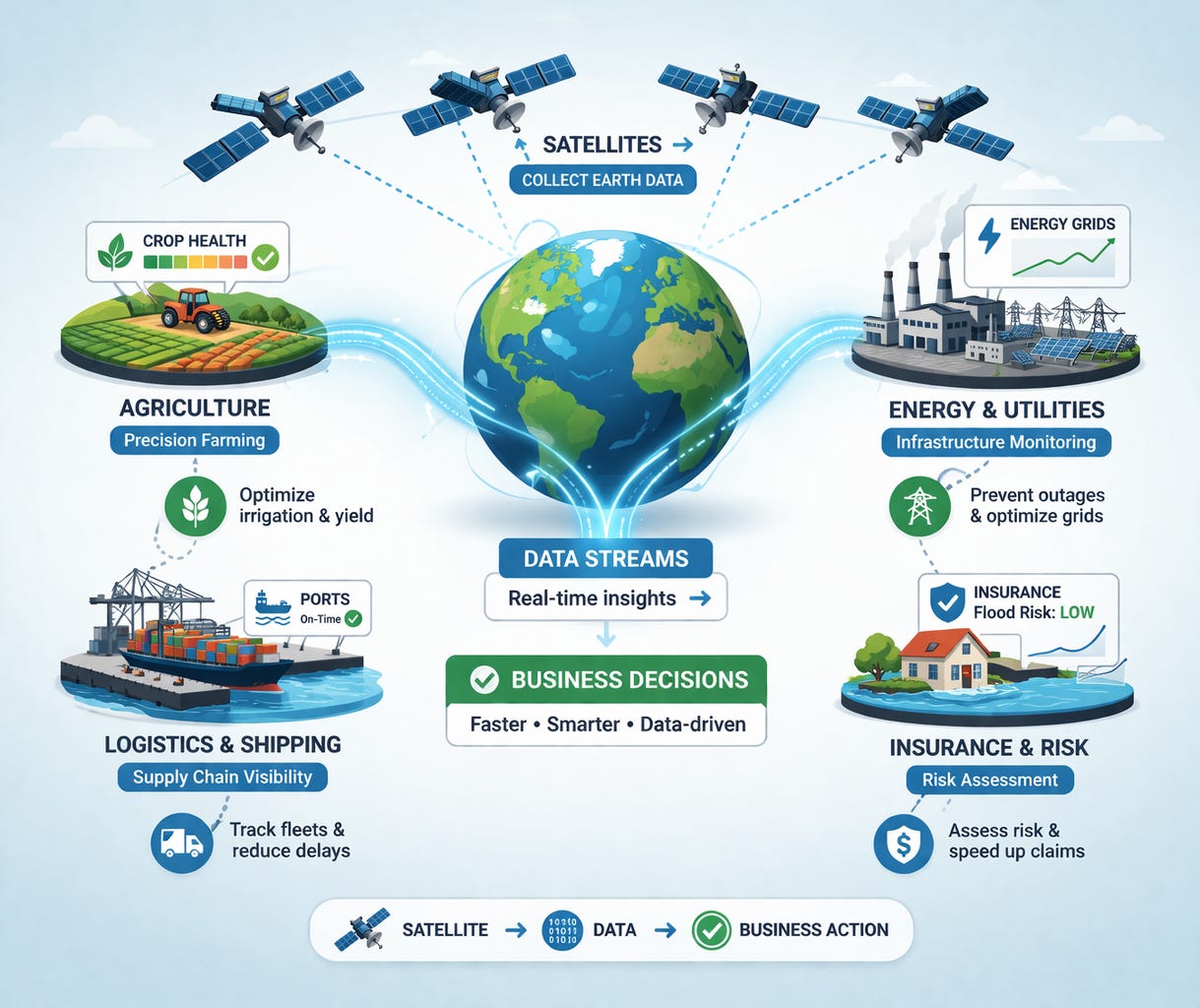
10 Industries Revolutionized by Space Technology in 2026
Discover how satellite data and space technology are transforming agriculture, insurance, logistics, energy, retail and more.

Companies across industries are increasingly looking to the sky for solutions, integrating space technology into their operations.
That shift is already underway. And it is moving faster than most industries realize.
In this article, we take a look at ten industries where satellite data, orbital infrastructure and space-based analytics are making a real difference.
Companies that embrace these tools now can work smarter, move faster and stay ahead of the competition.
We help you bring the benefits of space technology into your everyday business. Contact us at mpretkovic@cyclopcorp.com
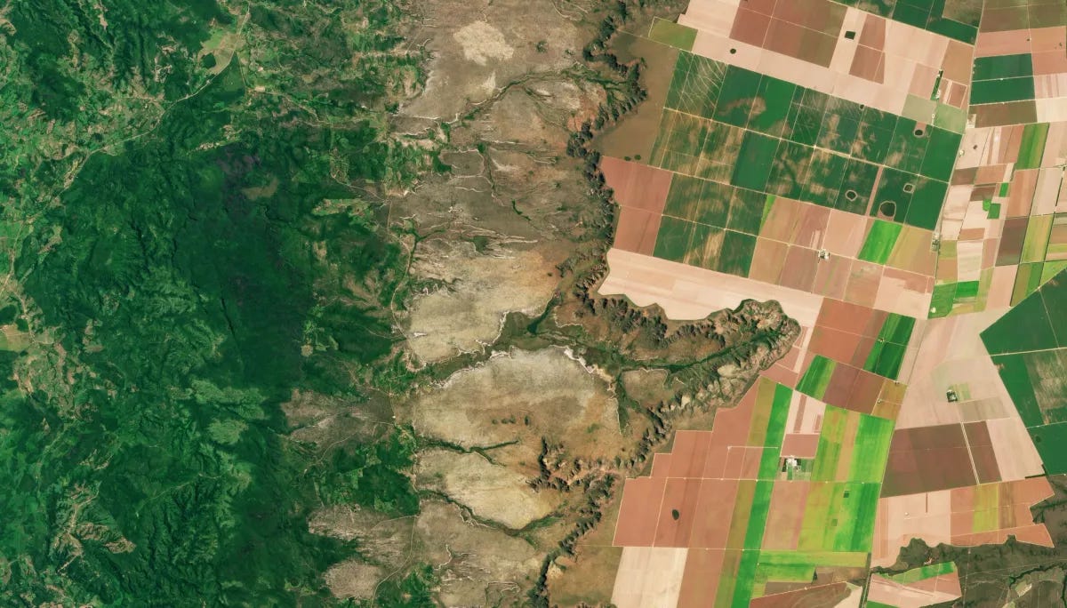
1. Agriculture: higher yields with less risk
Most farmers still scout fields on foot or by driving. That works for small operations. For large-scale agriculture, it is slow, expensive and you are always one missed infection away from losing a significant chunk of yield.
Planet Labs operates a fleet of roughly 200 satellites that image every land-based location on Earth daily. That daily cadence is the key. It means agronomists can track how a field is changing, not just how it looks at one point in time.
What that looks like in practice: Organic Valley, the US farmer-owned cooperative, partnered with Planet Labs to build a pasture monitoring tool that helped dairy farmers increase pasture utilisation by 20 percent. Before the programme, farmers estimated field recovery by walking paddocks. After, they received automated PDF reports generated from satellite data. The pilot started with around 20 farms and expanded to roughly 100 once the results were clear.
John Deere’s Operations Center integrates satellite-derived vegetation indices to generate variable-rate prescription maps sent directly to tractors. The same satellite pass that monitors crop health can tell a machine how much fertiliser to apply in which corner of the field. As we explored in Five things satellites can do for farming, this precision approach is already changing how food gets grown at scale.
The practical gains are real: earlier detection of crop stress, better-timed irrigation and fertiliser and more accurate yield forecasting. Fewer surprises at harvest means lower input costs and more competitive pricing.
Result: Better harvests and lower input costs, with less dependence on guesswork.
2. Insurance: faster and more accurate claims
After a major storm or wildfire, the traditional claims process is slow by design. An adjuster has to visit each property, document the damage and file a report. In large-scale events, that takes weeks. Sometimes months.
McKenzie Intelligence Services (MIS) built a platform that changes this. Using Vantor imagery, MIS published an initial exposure report on a major US tornado event within 24 hours, alerting Lloyd’s of London to the scope and location of damage before a single adjuster was on the ground.
Vantor’s WorldView-3 satellite offers ground resolution of approximately 30 centimetres per pixel and it carries shortwave infrared sensors that can see through thick smoke. During the 2019-2020 Australian bushfires, MIS used that capability to review more than 500,000 square kilometres of imagery and assess an AUD $250 million insurance claim, in a region where traditional imagery failed because of smoke cover.
The value to the insurer is objective, timestamped visual evidence. It speeds up valid claims and catches inconsistencies in fraudulent ones. The value to the customer is faster resolution at the worst possible moment.
Result: Quicker claim validation, lower fraud exposure and better customer outcomes at scale.
3. Logistics: smarter routing and fewer delays
Logistics is a data problem. You have vehicles, cargo, routes and conditions that are all changing at the same time. The companies that win are the ones that see that picture clearly and react faster than their competitors.
Kinetica combines real-time satellite data, weather feeds, traffic patterns and infrastructure status into a unified analytics layer. Think of it as mission control for a delivery fleet. Rather than routing based on a static map, operators can dynamically reroute shipments when a road closes, a port gets congested, or a weather event is tracking toward a key corridor.

The practical impact is not just fewer delays. It is the ability to predict delays before they happen and adjust proactively. A retail chain that knows three days early that its inbound container is likely to miss a port window can pull from a different distribution centre. One that finds out on the day loses the sale.
Result: Faster delivery times, lower fuel costs and far fewer reactive decisions under pressure.

4. Energy: predictive maintenance instead of failures
Energy infrastructure is expensive to build, expensive to fix and very expensive when it fails. A transformer failure or an unplanned pipeline shutdown does not just cost repair money. It costs grid reliability and customer trust.
Palantir Technologies’s Foundry platform is used by energy companies to integrate sensor data from equipment with external signals, including satellite imagery, weather forecasts and historical usage patterns. The output is early detection. Instead of waiting for a failure to trigger a repair call, maintenance teams can see patterns that indicate equipment stress and schedule intervention before anything breaks.
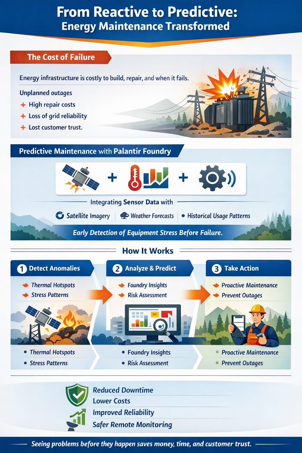
This is not a hypothetical workflow. Several major energy companies use satellite-derived data to monitor infrastructure in remote locations where sending a crew is itself a significant cost. Knowing a component is showing thermal anomalies from a satellite image is far cheaper than discovering the same fact after an outage.
Result: More reliable service delivery and significantly lower unplanned downtime costs.
5. Retail: real-time supply chain visibility
The supply chain disruptions of recent years exposed a core weakness in retail: most companies did not know where their inventory actually was until it was already late.
Satellite-based tracking and analytics platforms now monitor global cargo movement continuously. Port activity, shipping lanes, warehouse capacity and truck location are all visible in near real time. Retailers using these platforms can see a slowdown at a major port two weeks before it affects their shelves and react accordingly.
The largest operators use this visibility to rebalance inventory across distribution networks. If a shipment from Asia is delayed by ten days, systems can automatically identify which regional warehouse can cover demand and trigger a transfer. The shelf stays full. The customer never sees the problem.
Result: Fewer stockouts, better inventory positioning and higher sales capture during disruptions.
6. Mining: safer and more efficient operations
Mining happens in some of the most remote and geologically complex environments on Earth. Safety is a constant concern. So is efficiency, because the cost of getting ore out of the ground is high and margins depend on throughput.
Satellite imagery gives mining operations a persistent view of terrain. Change detection algorithms flag slope instability, erosion patterns and environmental anomalies that human inspectors might miss on irregular site visits. That translates directly into safer operations.
On the efficiency side, satellite data feeds into extraction planning. Knowing exactly where material is, how the terrain is shifting and where equipment is positioned allows operators to optimise the extraction sequence. Combined with autonomous machinery that communicates via satellite in areas with no ground network, some mining operators are running continuous operations with far fewer people in hazardous zones.
Result: Higher output per shift and measurably improved safety incident rates.
7. Telecom: network optimisation in real time
Telecom networks are massive and complex. An outage in one node can cascade. A capacity bottleneck during a large event can degrade service for tens of thousands of users at once. The traditional response is reactive monitoring and manual fixes.
Satellite data changes the monitoring equation. Coverage analysis using satellite imagery and terrain data lets operators understand exactly where signal reaches and where it does not. Combining that with real-time usage data from ground systems creates a predictive layer, where capacity shortfalls can be flagged before they become service complaints.
Direct-to-phone satellite connectivity, which companies like AST SpaceMobile are building, adds another layer. When ground networks are saturated or unavailable, satellite connectivity provides a fallback that the customer never has to manage manually. We covered the broader case for this shift in our AST SpaceMobile analysis.
AST SpaceMobile (ASTS) Q4 & Full-Year 2025 Results: Key Takeaways and Investor Signals

AST SpaceMobile (ASTS) reported Q4 and full-year 2025 results on March 2, 2026 .
Result: Fewer service disruptions, better coverage planning and a stronger fallback when ground infrastructure fails.
8. Disaster response: faster reaction times
When a flood, earthquake or wildfire hits, the first hours are the most critical and often the most chaotic. Emergency coordinators need to know which areas are affected, where roads are passable and where to send resources first. Ground-level reporting is slow and incomplete.
Satellite imagery addresses that directly. Vantor released more than 34,000 square kilometres of high-resolution imagery within days of the 2025 Los Angeles wildfires. NOAA embedded that imagery in a public-facing site so property owners could check on their homes while they were still evacuated. Emergency coordinators used the same data to direct resources toward the most heavily damaged zones.
The difference satellite data makes is not just speed. It is the ability to see a complete picture of an affected area from a single source, without waiting for road access or ground surveys. Every hour saved in the assessment phase means more effective allocation of resources.
Result: Faster, better-targeted emergency response and lower total damage from delayed action.
9. Real estate: smarter investment decisions
Real estate investment depends on reading where growth is going before it gets there. Traditional analysis uses census data, zoning documents and local market reports. All of those sources are backward-looking.
Satellite imagery and geospatial analytics add a forward-looking layer. Construction activity can be measured from orbit. Infrastructure development can be tracked in real time. Environmental risk, from flood plains to subsidence-prone land, can be assessed using multi-year imagery archives.
Commercial real estate funds and institutional investors use these tools to identify emerging growth corridors, monitor comparable property development and stress-test portfolios against environmental scenarios. Retail footfall analysis from satellite imagery, measuring car park density and entry patterns, adds another data point that financial models alone cannot provide.
Result: Better-informed capital allocation and fewer surprises after acquisition.
10. Security and defense: better situational awareness
Operational security is not just a government problem. Critical infrastructure operators, logistics companies and large multinationals all need communication systems that stay up under disruption, whether from weather, cyberattack or geopolitical events.
SpiderOak builds secure, autonomous communication infrastructure for space-based operations, using end-to-end encrypted systems that can operate without a centralised control point. In a degraded or contested environment, that architecture means communication continues even when parts of the network are compromised.
The broader shift toward resilient, distributed satellite networks is one of the defining trends in the space economy right now. For the investment angle, see our piece on the 2026 space investment landscape, where defense-adjacent satellite infrastructure is one of the clearest areas of capital flow.
Result: Communication continuity under pressure and higher operational reliability for critical systems.
What all of this adds up to
Ten industries. The same underlying technology stack. Satellites collecting data, analytics platforms making sense of it and business decisions improving as a result.
The pattern is consistent: companies that integrate satellite-derived data into their operations gain an information advantage over those that do not. That advantage compounds over time because the data gets richer, the models get better and the cost of access keeps falling.
The space economy is already worth several hundred billion dollars annually. Most of that value is being generated on the ground, by companies in agriculture, insurance, logistics, energy and retail that have quietly built satellite data into the way they operate.
If you or someone you know works in these industries, share this to show how satellite data can help them stay ahead.
We help you bring the benefits of space technology into your everyday business. Contact us at mpretkovic@cyclopcorp.com