
Five things satellites can do for farming
And where this is heading next

Satellites are quietly becoming one of the most practical tools in agriculture.
Not in a theoretical, ten-years-from-now way.
In a farmers-are-already-using-this way (at least large ones).
Here are the five applications worth understanding, plus three things to watch for what comes next.
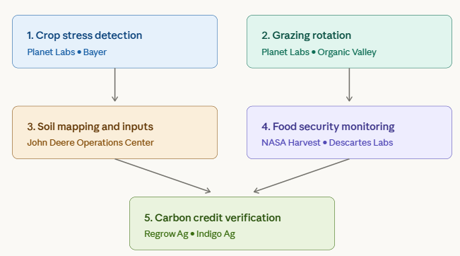
1. Spot crop stress before it becomes crop loss
Plants reflect near-infrared light differently when they are healthy versus stressed. Drought, disease, pest pressure and nutrient deficiency all change that signature before the problem is visible to the human eye.
A satellite can pick this up days or weeks early.
Planet Labs’ PlanetScope constellation captures near-daily imagery across all of Earth’s farmland. Bayer has partnership with Planet Labs to monitor crop trials across hundreds of thousands of hectares on four continents.
Earlier detection means cheaper intervention. That is the whole game in crop protection.
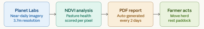
2. Manage grazing rotation with actual data
Organic Valley, the farmer-owned organic cooperative in the US, runs a programme where satellite imagery generates satellite-derived insights on pasture growth and variability to help guide rotational grazing decisions.
Each report shows which paddocks are recovering well, which are overgrazed.
Before the programme, farmers estimated this by walking fields.
After, they received an automated PDF generated from satellite data. The pilot started with around 20 farms and expanded to around 100 after it worked.
Rotational grazing depends on knowing when each paddock is ready. That used to be a judgment call. Satellites make it a data question.
3. Map soil variability and apply inputs precisely
Not all soil in a field is the same.
A single large block can have patches of different moisture, nutrients and organic content sitting right next to each other.
Treating the whole field identically wastes inputs in some zones and underapplies in others. Satellite imagery combined with soil sampling lets farmers build variability maps.
John Deere's Operations Center platform integrates satellite-derived vegetation indices to generate variable-rate prescription maps that are sent directly to the tractor.
The machine applies fertiliser, herbicide or seed at different rates in a single pass across the same field.
The right input, in the right place, at the right rate. That is the whole idea behind precision agriculture.
4. Monitor food security at a national scale
NASA Harvest used satellite imagery to monitor agricultural conditions across Ukraine throughout the war, tracking what was being planted, what was being harvested and where production was disrupted.
That analysis fed directly into global food security assessments for policymakers and humanitarian organisations.
Descartes Labs built its platform specifically for large-scale crop analysis, using satellite imagery and machine learning to produce national yield forecasts that help commodity traders and governments understand supply conditions before harvest data is officially published.
The same satellite that helps a dairy farmer manage paddocks can tell an analyst how much wheat a country will produce this season. The satellite does not change. The scale of the question does.
5. Verify carbon sequestration and find new farm revenue
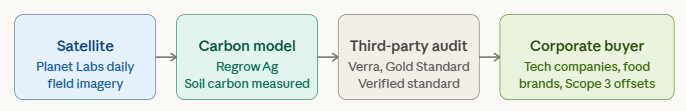
Agricultural soil carbon sequestration, storing carbon in farmland soil through practices like reduced tillage and cover cropping, can be sold as carbon credits to corporate buyers offsetting their emissions. The bottleneck has always been verification.
Regrow Ag uses Planet Labs imagery combined with soil carbon models to generate auditable records of farm practice over time. Those records underpin carbon credits that corporate buyers, including large technology companies making Scope 3 commitments, are purchasing. A farm running satellite-guided practice is not just cutting input costs. It is generating a new revenue stream from the same land.
Where this is heading next: three things to watch
The five applications above are happening now. The technology is moving fast enough that the next wave is already visible.
Keep reading with a 7-day free trial
Subscribe to Cyclop SpaceTech to keep reading this post and get 7 days of free access to the full post archives.